
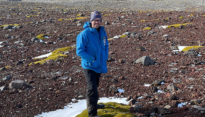
Prof David Hedding standing in a small pool of snow (Photo credit: Prof Werner Nel, University of Fort Hare)
While the eyes of the world have been fastened on Greenland and the geopolitics of the Arctic, critical developments have been unfolding in Antarctica, specifically on the sub-Antarctic Marion Island.
“One of the scary things I’ve noticed is how climate change has impacted the landscape, as well as various ecosystems and species,” says Unisa geomorphologist Professor David Hedding, who since 2003 has been conducting research on Marion Island, a South African island located almost 2 000 kilometres south-east of Cape Town.
“Many people do not know that there used to be a glacier on the island. Today, only remnants of this glacial ice remain, insulated and protected by the overlying sediment. Still, for all intents and purposes, the ice cap on Marion has disappeared,” Hedding says.
“If you compare photographs from the 1960s versus photographs that I and others have taken in recent years, you can see a drastic change in the landscape of the island.”
No longer icy and wet and underlain by peat (peatlands being a natural carbon sink), Marion Island has one of the fastest rates of warming of any place in the Southern Ocean and the planet. “Temperature has increased drastically since the turn of the century,” says Hedding, pointing to the current warming rate of between 2.3°C and 2.9°C on Marion Island and other sub-Antarctic islands.
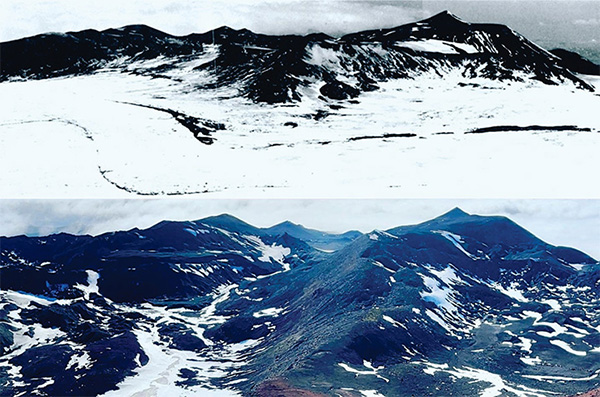
A contrast shot showing Marion Island's snow-capped landscape in the 1960s and a more recent picture, showing diminished snowfall (Photo credit: Earlier shot by Brian Huntley and more recent shot by Prof David Hedding)
This rapid warming has enormous implications for ecosystem functioning and various geomorphological processes that affect land surfaces – both on Marion Island and its surrounds and as a harbinger of the impacts climate change could have in southern Africa.
“Much of the research and insights we can garner from Marion Island we can use to hypothesise what will happen in southern Africa, giving us a regional perspective of climate change in the southern hemisphere,” says Hedding, who visits the island for six weeks every year and works with scientists from other South African universities, the British Antarctic Survey, the Norwegian Polar Institute and the French Polar Institute, among others.
One factor that makes Marion Island ideal as a site for climate change research is its relatively simple ecosystem, consisting mainly of grasses and shrubs, birdlife, and marine mammals. This simplicity makes it easy to monitor changes from climate shifts.
“There are very specialised species on the island, specifically adapted to survive there. If you change the parameters, those native species struggle, whereas invasive species have the plasticity to capitalise on and accommodate changes.”
Marion Island contains approximately 40% of the world’s wandering albatross population. These birds are now under huge pressure from the island’s most prolific and rapacious invasive species, mice.
“Mice typically eat a lot of invertebrates and vegetation. When food is scarce, and they are under stress, they start attacking and eating albatross chicks and adults. Those species are long-lived and endangered, and mice could have a profound impact on their ability to survive,” Hedding says.
“The island is far drier than it has been in the past, causing vegetation dieback, which is essentially exhibiting drought conditions. When you combine heat stress with drought conditions, it does not bode very well for the ecosystems that traditionally function in a very cold, wet environment.”
Apart from its simple ecosystem, other reasons that make Marion Island so singular as a climate change research site are its geographic location in the mid-latitudes of the southern hemisphere, where there is much more ocean than land.
“If you think of a world map, you have several continents in the southern hemisphere, and then you have a big gap with Antarctica in the south. Because there is so little land in the Southern Ocean, Marion Island provides us a platform from which to assess climate change in this ocean,” Hedding says.
“And because the island is a meeting point of ocean currents that distribute heat across the globe, you can readily see how shifts in ocean currents and climate can impact an island and then use those insights to see how climate change may impact southern Africa.”
The connection between the changes on an increasingly warm and drying Marion Island and the frequency and intensity of extreme weather events in Southern Africa is becoming more apparent, from flooding in Limpopo and Mpumalanga to the current drought in the Knysna area.
Based on scientific evidence across disciplines ranging from geomorphology and oceanography to palaeontology and marine biology, there is consensus among the scientific community that anthropogenic forcing – that is, human activity – is the main cause of ocean and atmospheric warming and associated landscape changes.
Hedding says consumers should not discount the impact – positive or negative – of their own behaviour.
“It all comes down to personal choice from a sustainability point of view. People underestimate the impact an individual can have by, for instance, installing solar or a solar geyser to reduce their reliance on coal-fired power, driving a hybrid car, growing their own vegetables, and avoiding plastic bags. These actions add up over your lifetime and can have a beneficial impact on the environment.”
* By Clairwyn Rapley, Directorate Research Support
Publish date: 2026-03-13 00:00:00.0
 Marion Island: The Unisa connection
 Unisa hosts Eighth Post-Budget Dialogue on fiscal policy and sustainable transformation
 Unisa pays tribute to women and their strength
 Unisa gains strategic insights at MWC 2026
 How AI is reshaping postgraduate supervision